Create Calgary: Our Places Still Speak
Artist Jared Tailfeathers explores significant historic sites on the traditional territory of the Blackfoot
This article was originally published in Create Calgary, a new arts magazine launched by Calgary Arts Development in 2022 to celebrate the work of artists who call Mohkinsstsis/Calgary home. You can pick up a free copy at public libraries, community recreation centres and other places where you find your favourite magazines. You can also read the digital version online here.
Four years ago, I embarked on a journey of growth and rediscovery. A chance as a colonized mixed-race Blackfoot person to get to know who I am culturally, historically and literally within the boundaries of my traditional territory. What does that mean? A traditional territory means my ethnocultural heritage walked, lived and was a part of the ecosystem here for millennia. My true cultural inheritance is the land, and everything here has a story and name. There are places on traditional Blackfoot territory that hold significance, whether we remember where all those important places are or not. I want to help connect old names to old places. Exploration of the evidence of art and methods of making that are still on the land is part of my cultural connection.
A Quest for Knowledge
Many things inspired this quest for greater knowledge: personal experience of living as a biracial indigenous man who did not live on-reserve; managing an identity crisis; racism (the casual 1990s kind); intergenerational trauma; lateral violence; religious ideological clashes; and unlearning toxic behaviours and systems. Most heavily, my disconnection from the culture of my ancestors due to the forced constructs of the existing foreign occupation (Canada). Other reasons that pushed me forward were personal losses: my father, Dr. Darcy Tailfeathers, who tragically died in a car accident in 1987; and my sister, Tara, and my estranged grandpa, who died during the research of the project. To connect and reconnect with them — my greater family, culture and heritage, and things we’ve (I’ve) lost culturally — always goes back to land and our relationship with it. Not just how to live off the land and appreciate it, but the knowledge of how all the ecosystems manage themselves best, with our involvement and stewardship.
I focused this desire into a planned three-part project that, about halfway through, became a five-part project. I called this idea, Traditional Methods of Making: Dog Trail, named for my two dogs, Dot and Chucky. Before my project began, and throughout the process, I worked with community members from the various Treaty 7 First Nations. That included the Blackfoot Confederacy, the Îyârhe Nakoda (Stoney Nakoda) Nations, the Tsuut’ina Nation and the Métis Nation of Alberta Region 3, plus other First Nations and communities who live within Treaty territory. I wanted to learn about the communities and their relationships with each other and the land. Through my work, I have had access to books, videos, Elders, Ceremonialists, historians, community members, leaders and artists. Much of my focus over the last few years has been to put permanent art up in Calgary Public Library locations, plan other permanent installations and events, promote my peers and community members, and directly visit the Treaty Nation communities to help build relationships, learn protocols and receive knowledge. These building blocks of knowledge and community informed the project idea and execution.
Back to the Land
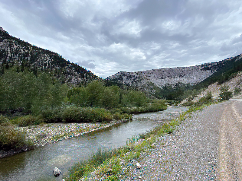
The traditional territory of the Blackfoot, pre-1650, was from the Continental Divide or the eastern valleys of the Rocky Mountains south of Jasper, including names for stories, songs, learnings, paintings and structures, and international relationships connected to the Banff corridor. It went as far as Lake Louise, the Devil’s Thumb Mountain and into the valleys containing the Paint Pots in B.C. It included the important river passes and river roads and went south to the Big Belt Mountains in Montana.
From there, it went east across the Yellowstone, Big and Little Big Horn, Tongue and Powder rivers, and then north past Grasslands National Park, Moose Jaw, Old Woman’s Lake, South and North Saskatchewan rivers, and every body of water.
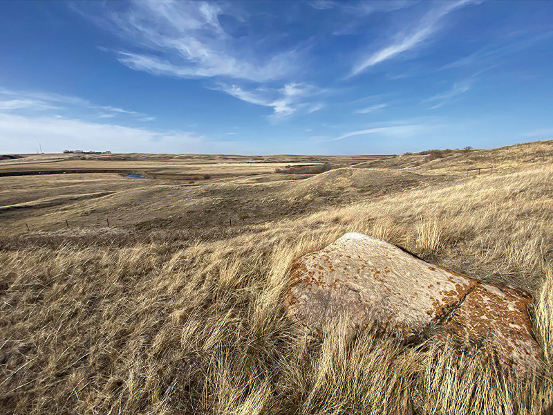
Every notable, useful and unique landmark, hill, cliff, hoodoo, glacial erratic rock, coulee and mountain under it were primarily Blackfoot use. It has been that way for no less than 1,500 years, and, as research in archaeology and correlating historic accounts keep growing, it goes back as far as 20,000 to 40,000 years.
To start, I visited all the Treaty 7 Nation and Blackfoot Confederacy reserves in present-day Alberta (with plans to go to Amskapi PiikaniBlackfeet in 2022). I explored the culture and sites at information centres and museums and known history. I then expanded to everywhere that caught my eye as I drove near it. I looked at topographical maps and waterways using the things I found out through my various resources and research indicators of uniqueness, beauty, usefulness and natural grandeur that would make the location traditionally important.
To make and design something new based on something old, I needed to understand the logic of the system in which these traditional methods were developed and adapted; the trade routes and material/resources of the Blackfoot Confederacy before the 1800s and the post-1800 world. I wanted to understand the reasons for living in this specific territory, the landmarks, the plants/animals, the sciences, tools and arts of the Blackfoot People. I needed to take a hands-on approach.
Blackfoot (Siksikaitsitapi) are appreciators of the land, the powers and medicines of nature and the natural monuments the Creator has made for us. I quickly learned that all major colonial settlements are founded on important Indigenous sites. All the major roads, railways and passes were our original routes. Some of them are likely tens of thousands of years old. I’ve been to hundreds of obscure locations with thousands of documented photos, and I will visit hundreds more before I’m through. There is some speculation on my part for the unconfirmed locations, but, to me, that is the beauty of it. So far, I have been about 85-to-90-per cent successful in confirming these places through Elders, historians, museum researchers, government officials and archaeologists.
Back to the Land
The traditional territory of the Blackfoot, pre-1650, was from the Continental Divide or the eastern valleys of the Rocky Mountains south of Jasper, including names for stories, songs, learnings, paintings and structures, and international relationships connected to the Banff corridor. It went as far as Lake Louise, the Devil’s Thumb Mountain and into the valleys containing the Paint Pots in B.C. It included the important river passes and river roads and went south to the Big Belt Mountains in Montana. From there, it went east across the Yellowstone, Big and Little Big Horn, Tongue and Powder rivers, and then north past Grasslands National Park, Moose Jaw, Old Woman’s Lake, South and North Saskatchewan rivers, and every body of water. Every notable, useful and unique landmark, hill, cliff, hoodoo, glacial erratic rock, coulee and mountain under it were primarily Blackfoot use. It has been that way for no less than 1,500 years, and, as research in archaeology and correlating historic accounts keep growing, it goes back as far as 20,000 to 40,000 years.
To start, I visited all the Treaty 7 Nation and Blackfoot Confederacy reserves in present-day Alberta (with plans to go to Amskapi PiikaniBlackfeet in 2022). I explored the culture and sites at information centres and museums and known history. I then expanded to everywhere that caught my eye as I drove near it. I looked at topographical maps and waterways using the things I found out through my various resources and research indicators of uniqueness, beauty, usefulness and natural grandeur that would make the location traditionally important.
To make and design something new based on something old, I needed to understand the logic of the system in which these traditional methods were developed and adapted; the trade routes and material/resources of the Blackfoot Confederacy before the 1800s and the post-1800 world. I wanted to understand the reasons for living in this specific territory, the landmarks, the plants/animals, the sciences, tools and arts of the Blackfoot People. I needed to take a hands-on approach.
Blackfoot (Siksikaitsitapi) are appreciators of the land, the powers and medicines of nature and the natural monuments the Creator has made for us. I quickly learned that all major colonial settlements are founded on important Indigenous sites. All the major roads, railways and passes were our original routes. Some of them are likely tens of thousands of years old. I’ve been to hundreds of obscure locations with thousands of documented photos, and I will visit hundreds more before I’m through. There is some speculation on my part for the unconfirmed locations, but, to me, that is the beauty of it. So far, I have been about 85-to-90-per cent successful in confirming these places through Elders, historians, museum researchers, government officials and archaeologists.
Choosing to Listen
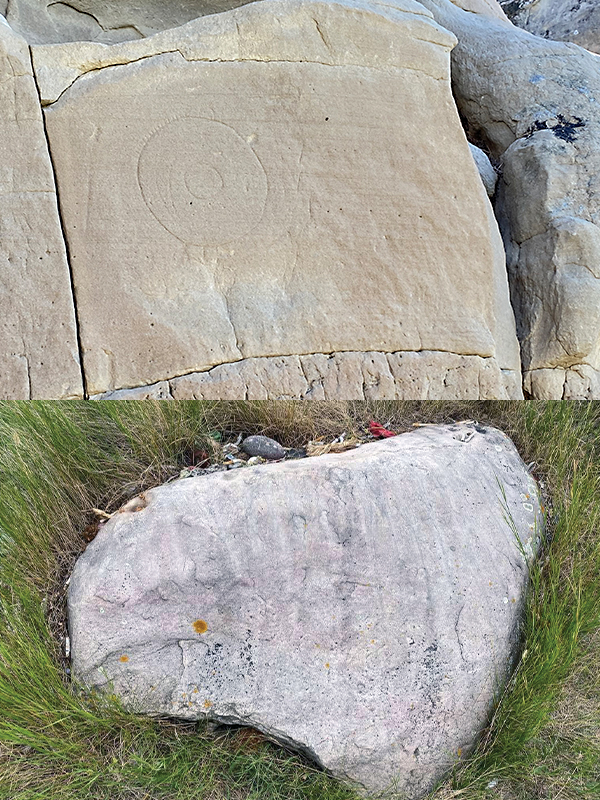
Going to these places has helped me feel a sense of urgency to protect the unlisted locations; many have been stumbled upon by disrespectful people and have been damaged beyond repair. We need to protect them and acknowledge that “Old Indian Legends” or creation stories aren’t just folklore and myth, but accounts of actual events at actual places. Many of these locations go unprotected and unacknowledged. Per our Treaty agreements, we should have access to these sites without fear of government or current-landowner reprisal. This needs to happen through civil and respectful communication with the current land occupants to educate and befriend them as we reconnect with our sacred spaces. There can be learning and appreciation on all sides and with all members of our Treaty 7 communities, who can regain their own relationships with these thousands-of-years-old cultural locations.
The more we bring our Knowledge Keepers who hold the stories of these places and their descriptions to those physical sites and share that knowledge, the quicker our reconnection to the land will be. There are unknown petroglyphs and pictographs yet to be confirmed; the art and language of history are there to show us more. This is exciting and satisfying, a glimpse into the territory before colonialism. Our places still speak to us; we just need to listen.
Jared Tailfeathers-Sikomh Kokomii (Calling Crane) is a Blood/Kainai Blackfoot and Caucasian multidisciplinary artist, musician/sound artist (music teacher), Blackfoot/Treaty 7 art researcher/amateur historian, author and inventor. He works in various media, arts and culture groups, collectives, committees and galleries. His work is often narrative-based, DIY and multimedia, with hints of traditional methods of making and interactive installations.
To discover the Top 11 places you can visit without permission, and why they’re significant, view the online version of Create Calgary.